The Philippine Institute of Volcanology and Seismology (PHIVOLCS) alongside international geological agencies has issued a critical emergency alert following a violent tectonic event off the coast of Mindanao. Officials confirmed that a massive 7.2 magnitude tremor struck the southern region early Monday, sending millions of residents fleeing into the streets.
In an official statement, disaster management authorities revealed that the epicenter was located at a significant depth beneath the sea floor. Consequently, the Pacific Tsunami Warning Centre immediately issued hazardous wave alerts for coastlines located within 300 kilometers of the impact zone, sparking widespread panic.
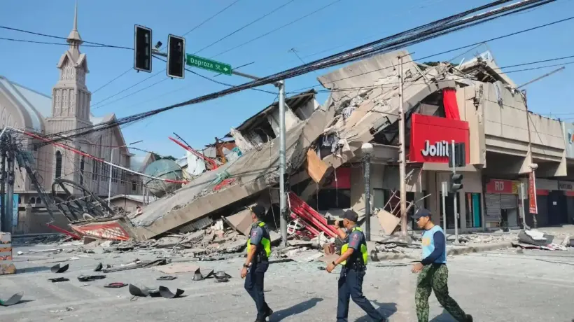
Furthermore, initial field reports from major cities like Davao and General Santos indicate widespread structural damage to older buildings and commercial malls. Emergency medical teams have been deployed to the worst-hit provinces, though severed communication lines and power grid failures are severely hindering early rescue operations.
Assessing the Immediate Destruction Caused by the Mindanao Earthquake
On a related note, seismologists warned that the region must prepare for a prolonged series of strong and potentially destructive aftershocks over the coming days. Residents are being strongly urged to inspect their homes for structural cracks and avoid returning to compromised concrete buildings until safety officials give clearance.
From their side, local government units have initiated mandatory evacuation protocols for low-lying coastal villages vulnerable to sudden sea-level disturbances. Emergency shelters have been rapidly established in inland schools and stadiums, where displaced families are receiving clean water and medical aid.
Meanwhile, international humanitarian organizations are closely monitoring the unfolding crisis, noting that the southern Philippines sits directly on the volatile Pacific "Ring of Fire". This geographic vulnerability regularly exposes the archipelago to intense tectonic movements, demanding constant state preparedness.
How Rescue Teams Mitigate Casualties After the Violent Earthquake
Additionally, historical data from previous oceanic tremors highlights that the first few hours following the main shock are the most hazardous for coastal communities. Marine experts explain that tsunami waves do not always appear as massive walls of water, but can manifest as rapidly rising, dangerous currents.
Following this major event, major transport hubs, including regional airports and maritime ports, temporarily suspended operations to evaluate runway and dock integrity. Engineers are prioritizing the inspection of critical bridges and highway overpasses to ensure supply routes remain completely open for emergency convoys.
As explained by civil defense teams, localized landslides in mountainous terrains have already blocked several key roads, isolating remote farming communities. Therefore, aerial reconnaissance teams are utilizing drones to locate trapped populations and map out safe ground navigation paths for military responders.
Vital Safety Protocols to Survive a Major Offshore Earthquake
Ultimately, as national authorities continue to assess the full scale of the structural and human impact, the absolute priority for citizens is strict compliance with safety guidelines.
Disaster response experts heavily advise individuals to stay tuned to battery-operated radios for real-time government updates and avoid spreading unverified social media rumors. By maintaining a state of high readiness and respecting official evacuation orders, local populations can significantly minimize life-threatening risks.


Comments
Log in to write a comment